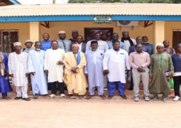

...and the UNTECH- the United Nations Technology Bank for Least Developed countries recently convened a capacity building training on the use of geospatial information technology applications for sustainable development.
Speaking at the event, Mod A.K. Secka, permanent secretary at the Ministry of Higher Education, Research, Science and Technology said science, technology and innovation are widely accepted as critical tools for poverty alleviation, sustainable development and transformation of nation.
PS Secka noted that advanced scientific and technological knowledge as well as innovation have made significant reductions in poverty and improvement in the quality of life in both developed and developing countries.
“For nations to develop they need transfer and utilise scientific and technological knowledge which is becoming a major source of their competitive advantage, wealth creation and improvement in quality of life. Thus, the government of The Gambia recognises the key role science, technology and innovation plays in fostering research and development in the building of critical human capital that The Gambia requires for the future knowledge- economy.”
He maintained that STI are said to contribute effectively to the diversification of the economy and sustainable use of natural resources.
He described science and technology as a key pillar in the National Development Plan 2018-2021, adding it also has clearly outlined a chapter on the role and the utilization of technology in the National Science Technology and Innovation Policy 2016- 2025.
He acknowledged that building capacities of local experts in key priority sectors of development has been core to his ministry’s mandate and programs.
“The training on the use and interpretation of satellite imagery with a specific focus on disaster risk management is relevant and timely as the country has not been spared by the effects of disasters through floods, storms and other climate change related disasters.”
The training, he added, came at a time when the ministry has set up a 65 percent policy turn-around in support and scholarship for students at GTTI in transforming GTTI to a university of Applied Science, Engineering and Technology.